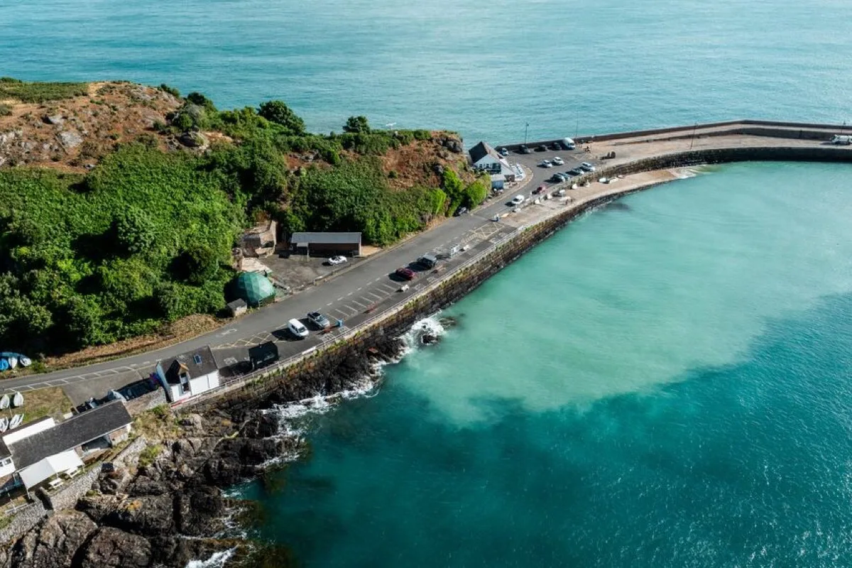
A rocky and shingle bay dominated by Jersey's long breakwater. It is widely used for swimming, kayaking, sailing and fishing rather than as a conventional sandy beach.
These predictions use St Helier, Jersey’s standard reference port. Local timing and conditions at St Catherine's Bay can vary slightly with weather and coastal geography. Times are shown in local Jersey time.
St Catherine's is shared by swimmers, boats and paddlers. A pilot recommended swimming area and swim platform are planned for summer 2026. Check the current harbour signs before entering the water.
St Catherine's is centred on its long nineteenth-century breakwater, which was begun in 1847 as part of an intended naval harbour. The wider scheme was not completed, but the surviving arm remains one of Jersey's most prominent coastal structures.
This is not a normal sandy beach. The shore is predominantly rocky and shingly, with smaller coves and areas of gravel, sand and wet sediment appearing through the lower tide. The principal activities are swimming, kayaking, sailing, angling and walking along the breakwater.
St Catherine's Sailing Club and Jersey Canoe Club use the bay, reinforcing its identity as an active watersports location.
At low water, the sea retreats from parts of the inner shore and reveals shingle, rocks, sand and soft wet ground. Some smaller coves become more visible, but the bay does not turn into one continuous sandy beach.
As the tide rises, the sea returns towards the slipway, harbour walls and upper shore. Higher water can make swimming entry more direct but also brings deep water closer to hard structures.
The tide can cover rocky hazards and change which exits are usable. A straightforward entry point at one stage of tide may become slippery, submerged, exposed above the water, busy with launching boats, or difficult to identify from the sea. There is no universal best tide without reference to the chosen entry point.
St Catherine's is an established sea-swimming location, but it is not lifeguarded and is shared with several other activities.
The bay can offer relatively protected water inside the breakwater, but it is not free from current, chop or boat traffic. Conditions near the end and outside of the breakwater can be substantially more exposed. Stay clearly visible and avoid crossing active launch routes.
Important considerations include:
St Catherine's is one of Jersey's principal kayaking bases. Jersey Canoe Club runs regular sessions here during the warmer months, and the bay is also used by sailors and other paddlecraft.
The breakwater offers some protection for launching, but conditions beyond it may involve stronger wind, tidal movement, open-water swell, rocky coastline and limited landing options. Novice paddlers should remain within organised or appropriately sheltered activity areas rather than assuming the breakwater makes the wider coast easy.
The breakwater is popular with anglers. Fishing lines may extend into water used by swimmers or paddlecraft, especially along the outer sections. All users should remain aware of one another rather than treating the pier as a dedicated swimming platform.
The breakwater provides a long, mostly level walk with broad sea views. Conditions become more exposed farther from shore.
Account for strong wind, spray or waves in rough conditions, unprotected edges, fishing equipment, the longer return walk and occasional maintenance closures. It should not be used for walking during severe weather merely because it has a firm surface.
Lower water exposes rocky and shingle areas around the inner bay and smaller coves. These provide limited rock-pooling opportunities but are less straightforward than the accessible sandy pools at beaches such as Plémont. Some areas may include soft sediment or permanently damp sand, and rocks near harbour structures can be heavily weeded and slippery.
St Catherine's is not one of Jersey's routine bathing-water monitoring locations, so there is no local sample to display. Results from nearby Archirondel do not apply here.
There is ample parking close to the breakwater, together with public toilets and disabled toilet facilities. The principal harbour and breakwater surfaces are comparatively level, making the viewpoint more accessible than many Jersey coves.
The natural shore remains rocky and uneven. Access to the water may involve slipways, harbour steps, shingle and wet stone at changing tidal heights, so the breakwater and facilities are far more accessible than access into the sea.
Facilities include:
St Catherine's is not lifeguarded.
No community photos of St Catherine's Bay yet. Be the first to add one and help build a picture of the beach at every state of the tide.
Add your photoOther bays and beaches close to St Catherine's Bay.
 East
East East
East North-east
 East
EastTides. Tide predictions are forecasts. Actual sea level is affected by atmospheric pressure, wind and waves. Always observe the sea and your surroundings.
Swimming. Sea swimming carries risks: currents, waves, rocks, submerged structures, boats and cold water. This page is for planning and does not confirm conditions are safe. Do not assume the beach is lifeguarded.
Facilities. Facilities and café opening hours change seasonally. Check directly before making a journey specifically to use them.
 Jersey