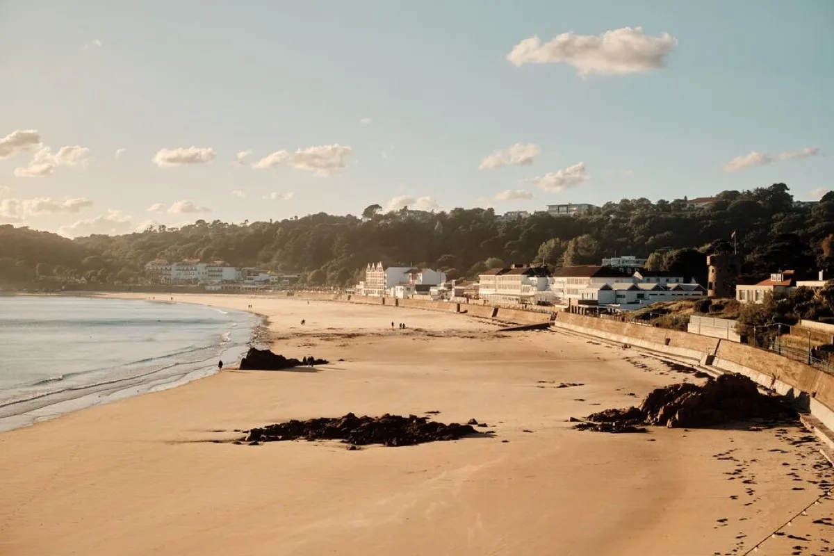
A broad, south-facing sandy bay with seasonal lifeguards, watersports and extensive seafront facilities. Low tide creates a wide beach and links the western end with Ouaisné, while higher water brings swimming closer to shore.
These predictions use St Helier, Jersey’s standard reference port. Local timing and conditions at St Brelade's Bay can vary slightly with weather and coastal geography. Times are shown in local Jersey time.
St Brelade's and Ouaisné become one continuous beach around lower water. The route around the headland covers again on the rising tide, so return before the sea reaches the rocks.
St Brelade's Bay is a broad, curved sandy beach on Jersey's south-west coast. The bay is backed by a promenade, hotels, restaurants and wooded slopes, making it considerably more developed than neighbouring Ouaisné and Beauport.
The beach faces broadly south and is partly protected from the prevailing westerly weather by the surrounding headlands. It can nevertheless receive waves, swell and wind from the south and south-west.
St Brelade's is one of Jersey's busiest beaches and one of the four locations covered by RNLI lifeguards during the 2026 season, with daily patrols from 23 May to 27 September, 10am to 6pm. No flags means no lifeguard cover.
At low water, the beach becomes substantially wider and the sea retreats across a gently sloping sandy shore. The distance to the water is noticeable, but generally less extreme than at St Ouen's Bay or Grouville. The falling tide also exposes more rocks around the edges and opens a sandy route around the western headland into Ouaisné.
As the tide rises, the sea advances steadily across the sand. Mid tide usually offers the most useful balance for a conventional beach visit: plenty of dry sand, with the water closer to the promenade and facilities.
Near high water, the sea reaches the upper beach and may leave a relatively narrow strip of sand in places; on larger tides or in wave action, water may approach the sea wall and access steps. Different users will favour low tide for walking and space, mid tide for general beach use, higher water for swimming without a long walk, and lower water for walking between the two bays.
St Brelade's Bay is widely used for swimming. The central sandy shore generally provides a gradual entry, while rocks are more prominent towards the ends. Its protected appearance is not an unconditional guarantee: conditions still vary with wind, tide, swell and watersports activity. During lifeguard hours, swim between the red-and-yellow flags; black-and-white flags identify areas used by surfboards and other craft.
Swimmers should consider:
RNLI lifeguards patrol St Brelade's Bay seasonally. For 2026 this is daily from 23 May to 27 September, 10am to 6pm. Swim between the red-and-yellow flags when displayed; no flags means no lifeguard cover. These dates are current for 2026 and may change in later years.
The sandy central beach and gently shelving shore make St Brelade's convenient for paddling through much of the tide. At lower water, the shallow edge may be far from the upper beach; at high water there may be less room between the sea and the promenade. Supervise children around watersports areas, the rocky ends, changing depth, incoming waves and crowded access points.
St Brelade's supports paddleboarding, kayaking, dinghy sailing, windsurfing and equipment hire, with operators offering tuition and hire. Powered inflatable rides have also operated in the bay, so swimmers and craft do not have unrestricted use of the whole shoreline. Look for the current beach flags and activity zones, keep clear of launching areas, and do not swim across routes being used by powered or sailing craft.
At lower tide, the western end of St Brelade's joins directly to Ouaisné around the rocky headland, and the route covers again as the tide rises. Return before the water reaches the rocks rather than relying on being able to scramble around the headland. The two beaches differ in access, facilities, atmosphere and supervision, so each has its own page.
Lower water exposes rocky areas at both ends of the bay, particularly near the route into Ouaisné and around the eastern end near St Brelade's Church. These contain pools and channels, although the main beach is predominantly sandy. Watch for slippery seaweed, the route around the western headland narrowing, pools filling behind rocks, sharp shells, and watersports equipment and boats nearer the centre.
The broad sand provides room for walking at low and mid tide, and the adjoining promenade offers a firmer route when the tide is high or for visitors who do not want to cross soft sand. The promenade is also useful for moving between restaurants, toilets and access points without walking on the beach.
St Brelade's Church and the historic Fishermen's Chapel stand close to the western end of the bay. They are significant landmarks worth a visit, though this remains a beach guide rather than a full heritage guide.
St Brelade's has several access points from the road and promenade, including steps and slipways. The promenade and roadside areas give relatively level views, but the beach itself is soft sand and not conventionally wheelchair accessible. BeachAbility provides balloon-wheel beach wheelchairs from the Churchill Memorial car park area, near the toilets and crossing. Accessible seafront, beach-wheelchair provision, ordinary wheelchair access across sand and access into the sea are all different things.
Parking is available at several points around the bay, including the Churchill Memorial area. The beach is very popular, so parking may fill quickly in warm weather, school holidays and weekends, and space directly beside a chosen section is not always available.
Facilities are substantial but spread along the bay:
The bay's southerly aspect gives good exposure to sunlight through much of the day, and the wooded slopes and headlands provide some protection from north and west winds. Southerly weather can still enter directly, and calm-looking conditions near the shore do not guarantee equally calm water beyond the bay.
No community photos of St Brelade's Bay yet. Be the first to add one and help build a picture of the beach at every state of the tide.
Add your photoOther bays and beaches close to St Brelade's Bay.
 South-west
 South-west
 South
SouthTides. Tide predictions are forecasts. Actual sea level is affected by atmospheric pressure, wind and waves. Always observe the sea and your surroundings.
Swimming. Sea swimming carries risks: currents, waves, rocks, submerged structures, boats and cold water. This page is for planning and does not confirm conditions are safe. Do not assume the beach is lifeguarded.
Facilities. Facilities and café opening hours change seasonally. Check directly before making a journey specifically to use them.
 Jersey